


Béatrice de Savoie

papou73
User

Length
8.9 km

Max alt
712 m

Uphill gradient
345 m
Km-Effort
13.5 km

Min alt
389 m

Downhill gradient
356 m
Boucle
Yes
Creation date :
2019-10-29 12:19:55.143
Updated on :
2019-10-29 15:09:15.692
2h46
Difficulty : Very easy

FREE GPS app for hiking
 SityTrail
IGN / Geographical institutes
SityTrail Plus
The world is yours!
About
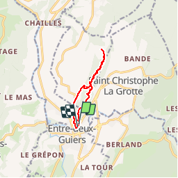
Trail Walking of 8.9 km to be discovered at Auvergne-Rhône-Alpes, Savoy, Les Échelles. This trail is proposed by papou73.
Positioning
Country:
France
Region :
Auvergne-Rhône-Alpes
Department/Province :
Savoy
Municipality :
Les Échelles
Location:
Unknown
Start:(Dec)
Start:(UTM)
715531 ; 5035177 (31T) N.
Comments